


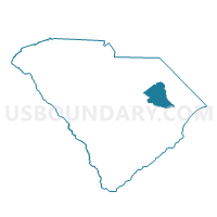
Elim-Glenwood Voting District, Florence County, South Carolina
About
Outline

Summary
| Unique Area Identifier | 665725 |
| Name | Elim-Glenwood Voting District |
| County | Florence County |
| State | South Carolina |
| Area (square miles) | 32.64 |
| Land Area (square miles) | 32.60 |
| Water Area (square miles) | 0.04 |
| % of Land Area | 99.89 |
| % of Water Area | 0.11 |
| Latitude of the Internal Point | 34.06275030 |
| Longtitude of the Internal Point | -79.84931900 |
Maps


Graphs
Select a template below for downloading or customizing gragh for Elim-Glenwood Voting District, Florence County, South Carolina


Neighbors
Neighoring Voting District (by Name) Neighboring Voting District on the Map
- Cowards No. 2 Voting District, Florence County, SC
- Effingham Voting District, Florence County, SC
- Oak Grove-Sardis Voting District, Florence County, SC
- Salem Voting District, Florence County, SC
- Savannah Grove Voting District, Florence County, SC
- Tans Bay Voting District, Florence County, SC
- Timmonsville 2 Voting District, Florence County, SC
Top 10 Neighboring County Subdivision (by Population) Neighboring County Subdivision on the Map
- Danwood CCD, Florence County, SC (15,155)
- Coward CCD, Florence County, SC (4,006)
- Olanta CCD, Florence County, SC (3,879)
- Timmonsville CCD, Florence County, SC (3,695)
- Sardis CCD, Florence County, SC (2,978)
Top 10 Neighboring Unified School District (by Population) Neighboring Unified School District on the Map
- Florence School District 1, SC (96,463)
- Florence School District 3, SC (20,584)
- Florence School District 4, SC (6,768)
Top 10 Neighboring State Legislative District Lower Chamber (by Population) Neighboring State Legislative District Lower Chamber on the Map
Top 10 Neighboring State Legislative District Upper Chamber (by Population) Neighboring State Legislative District Upper Chamber on the Map
Top 10 Neighboring 111th Congressional District (by Population) Neighboring 111th Congressional District on the Map
Top 10 Neighboring Census Tract (by Population) Neighboring Census Tract on the Map
- Census Tract 15.04, Florence County, SC (5,939)
- Census Tract 23, Florence County, SC (4,006)
- Census Tract 24, Florence County, SC (3,879)
- Census Tract 15.05, Florence County, SC (3,875)
- Census Tract 26, Florence County, SC (3,695)
- Census Tract 25, Florence County, SC (2,978)
- Census Tract 15.06, Florence County, SC (1,971)